October 8, 2021
Cyclones on a warming planet
IST Austria’s first climate scientist studies how global warming affects precipitation extremes.
Every year, tropical cyclones cause billions of euros in damage and claim hundreds of lives. On a warming planet they could become even deadlier, says Caroline Muller. With the help of hurricane hunters, satellites, and applied mathematics the first climate scientist at the Institute of Science and Technology (IST) Austria studies the response of the hydrological cycle to global warming.
IST Austria: The past summer was another summer of extremes. Germany and Austria where hit by devastating floods. How did you experience it?
Caroline Muller: It made me want to go back to work to understand it better. What we can say is that with more greenhouse gases in the atmosphere and warmer temperatures there are certain changes. One of them is more moisture. Warmer air can hold more water vapor. So within the extreme storm of the past summer more water has been transported that means more intense precipitation. One of the consequences of global warming is to enhance precipitation extremes.
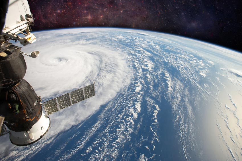
You have a background in aerospace engineering and applied mathematics. If you could be on the International Space Station and look down on the Earth, what would you look out for?
Muller: I don’t think they would be able to take me back to earth ever again, if it wasn’t for my family and friends. I would look at the clouds: They look spectacular, they take on different shapes, and in terms of physics, they are extremely intriguing. There are many processes involved at many different scales – from little droplets to turbulences, to the formation of cloud clusters at the scale of a tropical cyclone. Our intuition is that if you put cold water in warm water, you get warmish water. When you look at a cyclone, however, you have this very abrupt transition from the eye without clouds and the eye wall, which is a super steep wall of clouds. You want to stir it with a spoon but this sharp transition stays. It makes sense once you look at the equations and the dynamics.
How do you study tropical cyclones from Klosterneuburg?
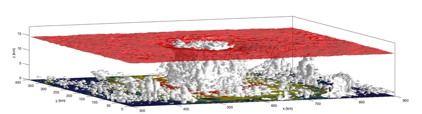
Muller: To study cyclones, luckily, you don’t need to sit in a plane like one of the hurricane hunters that fly through hurricanes, to have access to the data. It’s a very convenient time to be a climate scientist. Most of my work is with idealized numerical simulations in high resolution. I use mathematical tools to understand what the simulations are saying. For instance, if you do simulations of climate change, you look at how precipitation extremes respond to a change in temperature. The simulations show that they intensify at a rate of about 7% per degree of warming. For a warming of three degrees, it intensifies by 21% – that is a significant intensification.
Are cyclones becoming more dangerous due to global warming?
Muller: The global climate models are not perfect, but they give us some answers. The number of cyclones does not seem to change much, but their intensity increases. One of the reasons is that tropical cyclones get their energy from the ocean. Of the additional energy the earth has received due to greenhouse gases, 93% are absorbed by the oceans. Consequently, they are warming. Tropical cyclones love warm water. Another thing is that sea levels are rising. So, all the costal populations are more at risk.
3 factors that make cyclones destructive:
• Strong winds: Tropical cyclones can sweep across the landscape with wind speeds of up to 300 km/h. At wind speeds of 100 km/h and above, people can barely stay on their feet.
• Heavy rain: Especially slowly moving cyclones bring many times the average amount of water into a region causing flooding.
• Sea-level rise: Tropical cyclones pile up the ocean’s water along the coast creating tidal waves that can exceed ten meters in height. Rising sea levels due to global warming and increasingly densely populated coasts make cyclones all the more destructive.
One of the open questions in climate research is why some low-pressure areas strengthen into cyclones and others don’t. What does radiation have to do with it?
Muller: Clouds interact with radiation a lot. We know that from the solar radiation: Clouds shield us from the sun. That is also true for thermal radiation. The surface of the earth is trying to emit the heat to space to create an equilibrium with the incoming radiation from the sun. But part of this thermal radiation is trapped by clouds that reemit it partially towards the surface. That is the greenhouse effect. In my research I, among other things, focus on the question, if these radiative interaction of clouds with the air matters in the formation of tropical cyclones. We found that it does accelerate cyclone genesis in the idealized simulations that we use. By interacting with radiation, the clouds generate temperature gradients, which generates motion – the warm air will rise the cold air will descend. These circulations match the circulations within a tropical cyclone. So, they would accelerate the dynamical set up of the phenomenon.
The data that goes into the climate models comes from satellites, among other sources. You yourself are also involved in a planned satellite mission by the European Space Agency called Harmony. What is the mission’s goal?
Muller: The goal is to look at the tropical oceans and the atmosphere above tropical oceans at a very high resolution. There are several instruments on the proposed satellites that would measure the winds near the surface. They are especially difficult to measure from satellite because you see everything from the top – the closer to the surface something is, the more difficult it is to get accurate measurements. With these new satellites, we could measure the wind near the surface down to a few kilometers of horizontal resolution. That would be extremely useful because clouds are closely linked to the circulation.
The anatomy of a tropical cyclone
Tropical cyclones emerge around the equator at latitudes between five and 20 degrees. In the Atlantic and North Pacific, they are called hurricanes, whereas, in Southeast Asia they are referred to as typhoons. Its calmest place is the cloudless eye in the center – a low pressure area. It is surrounded by a wall of clouds carrying large water droplets that rotates clockwise in the Southern Hemisphere and counterclockwise in the Northern Hemisphere. The vase shaped eye wall spans from the surface up to 10-15 kilometers in height. Winds are strongest close to the surface, where the cyclone touches buildings when it makes landfall.
What are you currently working on?
Muller: I’m very excited about a new tool that we have. The climate models we’ve been using so far have quite a coarse resolution. Recently, teams all around the world started developing intermediate global models with a super high resolution. They don’t run as long as comprehensive general circulation models because that would be too expensive. But, for the first time, we have global high resolution simulations of the atmosphere motion. The project is called Dyamond and it is still ongoing. In the next simulations, we will see how the atmosphere is interacting with the ocean. That is something I’ve already worked on in idealized simulations but these new simulations are realistic. So, it would be very interesting to check if we get similar results.
How does it feel to be a climate scientist at a time when our climate is changing dramatically?
Muller: I didn’t think about the changes we are facing for a long time, because I just loved the science of it. It really hit me when I started working in the Mediterranean region. It’s a very sensitive area, especially Spain and Portugal. We are heading towards a climate that will not be bearable in many parts of the planet. Sometimes it gets very depressing and worrying. But with the difficulties associated with a changing climate we also have a lot of opportunities and I think we have taken a lot of turns that were necessary from a climate perspective but that also led to economic development. I think there is hope that if we really face climate change and learn to understand it, there is room to do something that is actually positive for humanity. It would be great if I could contribute to the understanding of these processes. That’s what I try to do.
